Welcome to the Community View section of the website. This area is dedicated to articles of interest, community information and local topics that are submitted by members of the public or guest writers. It is also the main section dedicated to the Youth Media Group Project.

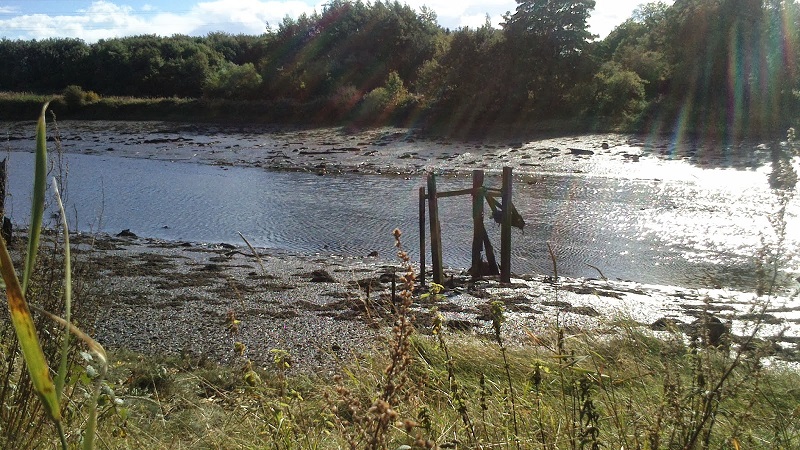
I often walk along the southern banks of the River Blyth from the site of the old Bates colliery to Furnace Bridge at Bebside. At low tide on the other side of bank are the visible, but incomplete, remains of wooden poles sticking out of the mud. One set is near the mouth of the Sleekburn, the other near the A189 road bridge. The anaerobic conditions, being submerged for long periods, have no doubt aided their preservation.
| Remains of a Linear Wooden Structure at Mouth of Sleekburn |
.jpg) |
| Wooden Structure River Blyth North Bank Opposite Kitty Brewster |
A first guess would be that they supported some kind of jetty. But what was their exact purpose? During which period were they used? And what did they look like when operational?
I looked first at the Ordnance Survey mapping of the 1850-60s which indicated the lines of wagonways terminating at the wooden structures. Clearly the structures were jetties, or staithes, for the unloading of cargo onto boats. The wagonways were already labelled as disused on the 1st edition mapping.
| 1st Ed OS Map c1860 Showing Old Wagonways Marked in Yellow (click to enlarge) |
The line of the two wagonways lead to what is labelled as Bedlington Colliery. The wagonway then extends from Bedlington Pit first North and then West towards Netherton.
The wagonway that terminates near the A189 (Spine Road) road bridge heads in north-westerly direction, for a few hundred metres, before turning sharply northwards at the terraced housing of Puddlers Row, which no longer exists.
| Greenwood's Map of Northumberland 1828 |
Greenwood's 1828 map of Northumberland does not indicate that there was a wagonway from Bedlington Pit to the mouth of the Sleekburn. In fact, the Bedlington pit labelled on the 1st edition Odnance Survey map of c.1860 was Bedlington A Pit, which according to the Durham Mining Museum website was opened in 1838. The Sleekburn wagonway must therefore post-date 1838. It was clearly a short-lived utility only finding useful service during the 1840-50s. Wagonways were the early railways that carried horse-drawn wagons. The rails were constructed from wood.
A major mineral railway line is shown on the 1860 mapping running roughly North to South and passing the Bedlington A Pit. The line is still in use today. The construction of this line would have made the transport of coal easier, quicker and less expensive than shipping via the River Blyth. The Sleekburn wagonway would have been quickly rendered obsolete.
The wagonway near the Spine Road bridge was presumably also rendered obsolete by the new railway. But it had a longer history. So when was this wagonway constructed and why?
The Sites and Monuments record, as published on the www.KeystothePast.info website, indicates that the wagonway was shown on a map dating from 1787 running from a pit called Bedlington to the north bank of the River Blyth. It also appears on a map of the Hirst Head Estate dated 1837.
Not having been able to see the map I do not know where the pit would be. Presumably though it was somewhere on the wagonway route as indicated on Greenwood's 1828 map and a small-scale primitive venture. Possibly it was at the site of what was to become Bedlington A pit.
The River Blyth is where the wagonway terminates at this point. At the lowest point of the tide the river is reduced to no more than a trickle. Greenwoods map indicates that in 1828 this location was actually a fording point on the river. Mapping also indicated that the wagonway ran through a small tunnel before emerging out onto the river bank. The Sites and Monuments record also indicated that the tunnel still exists and was recently consolidated.
A site visit revealed that an interpretation display board had been erected by the local authority at the mouth of the boarded up tunnel, which is also inaccessible due to the overgrown vegetation. This is what it revealed:
The tunnel in front of you is part of a wagonway that linked the Engine Pit (at Choppington) to coal staithes on the River Blyth. A branch line ran from here to the nearby Bedlington Ironworks (by Furnace Bridge). The wagonway was the first in the world to be built with Bedlington-made malleable iron rails... Malleable iron rails were used all over Britain notably on the Stockton and Darlington Railway in 1825.
.jpg) |
| Overlooking the Tunnel onto the line of the Wagonway looking towards the River |
Even at high tide the larger sea-worthy vessels would have been unable to navigate this far upstream to the jetties. We can speculate that the reason the owners of Bedlington A pit went to the expense of constructing a wagonway to the mouth of the Sleekburn, further downstream, was that the water was deeper for longer periods, allowing for longer operation times. A nearby block of terraced housing named Keelman's Row is shown on the 1st Edition OS mapping and could be a clue as to how the transport system worked. There was also a Keelman's Row much further downstream in Blyth.
Keelmen formed a large and well-known section of the population of Newcastle in the 18th century. This is from Wikipedia:
They were known as a close-knit group of aggressive, hard-drinking men. John Wesley, after visiting Newcastle, described them as much given to drunkenness and swearing [Wikipedia].The keels were vessels of narrow draught that were loaded with coal and then taken downstream to the larger collier boats where the cargo was offloaded to be transported by sea: a skilled operation. The colliers were unable to travel upstream as far as the Newcastle collieries: the river at this time was too shallow. According to the Keelman article on Wikipedia: "By 1700 there were 1,600 keelmen working on the Tyne in 400 keels".
In 1598 keels were used in the river Blyth, as by the inventory of the effects of Robert Widdrington in that year it is stated that he owned half a coal keel at Cowpen.
The use of keel boats on the Blyth is not well documented elsewhere either. Clearly there was only a small fraction of the amount of keelmen working on the Blyth as compared to the Tyne. The harbour at Blyth was not developed until the 1850s. Prior to this time the amount of ships able to use the harbour was limited.
A closer study of the jetty, or staithes, structure indicates some remains of a feature, attached to the main structure by way of a swivel, which indicates a more sophisticated mechanism than is obvious at first glance. It is possible that the staithes may have been improved and expanded when it also began to be used by the nearby ironworks.
.jpg) |
| Closer view of the Staithes Structure |


